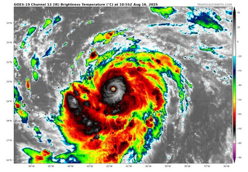

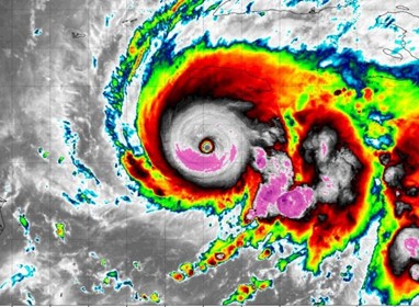
On October 28th Hurricane Melissa struck Jamaica at its peak strength as an 185 MPH Category Five Hurricane. With it tying the record of the most intense hurricane landfall in the history of the Atlantic, and the strongest landfalling storm by far in Jamaica history. At landfall it had one of the lowest barometric pressures ever recorded in the Atlantic at 892 millibars at landfall. This storm broke all of those records while cutting through western Jamaica like a buzzsaw.
Mellisa originally began as a tropical wave that creeped across the Atlantic throughout mid-October, it stayed originally stayed disorganized from hostile conditions as it crawled past the Windward Islands and eventually nearly stalled southeast of Jamaica. Where it stalled made all the difference with how strong it got. The sea surface temperatures were a steaming 86-88 degrees and most importantly the ocean heat content was extremely high. Ocean heat content was instrumental to this storms intensification because it is the extent of the heat in the water as you go deeper down, which helps storms intensify quickly because it’s almost unlimited fuel. In this area of the Caribbean, it was extremely high because of the heat from this summer, but also because of this season’s lack of activity in that area which allowed for warmer waters to go deeper down. When Melissa stalled over it had unlimited fuel and this depth of heat enabled it to keep intensifying as it stalled, because usually storms cause an upwelling of cooler water if they sit over an area for a long time, the thing with Melissa was that there was nothing but warm water even deep down. The environment was also super supportive after a few days with no wind shear or dry ai to hamper the storms development.
However, what gets even more interesting about the storm was how it intensified, it exploded into a major hurricane almost overnight and then wouldn’t stop strengthening. Usually when hurricanes get to a peak intensity, they go through a cycle called the eyewall replacement cycle, this weakens the storm because the main eyewall core moves out and becomes weaker as a new one forms in its place. In Melissas case this did not happen, the storm’s structure remained the same and it only got stronger, strong enough to toss the Hurricane Hunter Orion aircraft around like a toy. According to one dropsonde reading from the NHC, there was a surface gust of 252 mph, which if verified could be another world record.
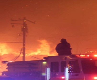
When that unleashed on Jamaica the effects were catastrophic. Any areas caught in the eyewall faced damage that like an EF4 tornado and reshaped the landscape. Extreme surge and rainfall also caused massive flooding inland and in the river deltas that were the towns caught in the center of storm. Videos have emerged of roofs being tossed, forests flattened, and most sturdy buildings suffering serious damage. Initial estimates from Jamaica’s government place damage at around -8 billion dollars across the island alone, with AccuWeather projection around 50 billion in damages in total from the storm. The long-term effects place Jamaica in a difficult situation, with Jamaica dependent on agriculture and tourism this storm heavily devastated both industries. The P.M of Jamaica emphasized the GDP output this year could be reduced as much as 32%. Effects of the storm were not isolated, for almost a week portions of the Caribbean like Haiti and Cuba suffered constant flash flooding and landslides as the storm sat in place.
There have already been recovery operations beginning. With relief flights coming in from Florida and other British commonwealth countries offering aid and assistance. However, for Jamaica in particular many basic needs need to be restored as some communities are still partly cut off from the storm. Recovery is likely to be a long road for Jamaica, and there will likely be a huge hit to the economy for a long time.